Surveying with a drone
Surveying and mapping professionals have been using both photogrammetry and LiDAR for measurement and survey purposes for a long time now.
As such, the question about which is more effective has come up in various ways. In fact, the contention that photogrammetry would make laser scanning obsolete is one that was making waves not too long ago.
But for anyone who takes the time to look at both technologies, it’s immediately evident that “better” and “obsolete” aren’t words that really belong in this conversation.
It’s true that drones have made it easier than ever to create 3-D models, and there are undoubtedly people who are convinced a cheap camera and drone will be all you need to gather the appropriate data for a given project.
On the flip side, there are people whose only experience has been with LiDAR, compelling them to ignore or disparage photogrammetry. Anyone making either claim is only looking at a specific application of the other technology, or his or her motivations are being driven by something besides what is going to be best for a given user.
There are simple and in-depth ways to look at the differences between the two technologies, and UAVs (unmanned aerial vehicles) have given the conversation a whole new dimension. Professionals who work with these tools on a daily basis understand their strengths and limitations better than anyone, and they can provide critical insights around how to best leverage the technology.
Drones as a game changer
Drones have brought photogrammetry to the forefront in an incredibly powerful way, enabling more developed conversations. Rather than convince people a 3-D model can be constructed via photos, a number of people have moved on to ask about the logistics behind the process.
Much of this is because people recognize what can be done when the right cameras and sensors are attached to a drone, but LiDAR has been impacted as well.
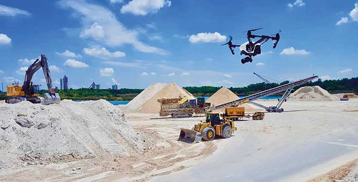
The perspective a drone provides is far removed from traditional capture methodologies, as users can control the drone to fly at a certain elevation, to get a certain percent overlap, as well as plenty of other angles and views. Photos courtesy of DroneView Technologies
“UAV LiDAR systems open up a new market which we call micro-mapping,” says Grayson Omans, CEO of Phoenix Aerial Systems. “Conventional aerial LiDAR service providers typically turn down projects that are less than 5 sq. km due to high mobilization costs, but now with UAV LiDAR systems service providers can quickly mobilize and complete this size job in less than a day.”
The perspective a drone provides is far removed from traditional capture methodologies, as users can control the drone to fly at a certain elevation, to get a certain percent overlap, as well as plenty of other angles and views. The volume of data they gather allows users to get what is often the perfect image set that will meet the majority of their needs, which is far different from controlling a human who’s walking around in a space and trying to make sure they get sufficient imagery.
Drones have opened up the industry to people of all types of skill levels, and that has created problems in terms of expectations. However, it’s also encouraged certain organizations to take on capture data themselves, and the results of such undertakings are often mixed.
“The challenge now is that people can go to a big box store to buy a drone and hook it up to a service that provides flight automation and data capture,” says David Boardman, CEO of URC Ventures. “So we end up with people who are asking why this is so hard when there are low-cost solutions that are available which they can then go do themselves. Those are the sorts of people that are running into known issues and known problems, just because we have so many new people in the space who are not GIS professionals or surveyors.”
Experiencing pains is an issue users and organizations will go through, but sorting out how and why their approach makes sense for a given project needs to be a priority.
Accuracy is everything
When looking at both photogrammetry and LiDAR options, the priority for users is often centered around accuracy. You need to know what accuracy you really need to achieve.
LiDAR gives users the ability to be more accurate, but it is difficult to gather high resolution from LiDAR data. Users need to supplement that kind of data with imagery because, with cameras, you can be as close or far as necessary. You could be using a macro lens, and you’re still using the same software and engines that can churn out various levels of accuracy and detail.
Of course, budget considerations are often just as important to consider, but familiarity with a certain tool might be of even greater importance.
As a general rule, people will gravitate toward what they know and what is most affordable, which is an issue that extends to all technology choices. There’s always the balance between what would be ideal, what you can afford, and what you know.
“Too often people approach a problem with whatever technology they have or whatever technology they’re selling,” Boardman says. “So you’ll get people force-fitting photogrammetry and force-fitting LiDAR because they know those technologies, when the right approach is to step back and determine the business objective as well as the budget. That can dictate a lot of the selection process. That’s the biggest driver I see in the industry, because you have to start with what you’re trying to accomplish and then go backwards from there.”
Often, people are quick to think photos are cheaper, and for the most part that is true. Still, there are typically underlying costs in getting a photo-based solution to work consistently, robustly and reliably that people don’t know about or think through. The cost to reoccupy is very expensive, and it’s the last thing anyone wants to do.
Know what to ask
When looking at photogrammetry and LiDAR, what’s essential to understand is that it’s not about one being better than the other. Both technologies have their applications, and they also have their limitations.
LiDAR is more expensive and it can be lower density than photogrammetry, but what people don’t understand are the conditions that need to be met for photogrammetry. Neither is a tool for every job.
“There are some obvious limitations and strengths of each technology that will drive a decision,” Boardman says. “If you’re doing something in the dark you’re not going to be want to take pictures. You could put some lighting up and things like that, but then you start to lose the benefits of the camera. Then it comes down to questions of scale. How big of an area are you talking about? Can you collect it with one person with a LiDAR unit, or do you need to send out 20 people with cameras?
“There’s a wide array of factors that influence the decision of going with lasers or photos,” he adds.
Considering budgetary limitations, a project might not even get off the ground if limits are pushed too far. That can force someone to choose the most economically feasible option, regardless of the other details.
It’s a choice some people have to make, but moving forward with a low-cost solution can mean risks in terms of the quality of a given output or deliverable. People need to be aware of those risks, and it’s important to properly evaluate how the technology you’re using will impact the potential success of a project.
“The drone does not matter as long as it can fly the mapping pattern and a mechanism is in place to fire the camera at the appropriate stations to achieve proper coverage,” says Lewis Graham, president and chief technical officer at GeoCue Corp. “The camera does matter. If you do your homework, the desired goal is achievable. Starting out cheap is actually a pretty good idea for a do-it-yourselfer. You are going to crash and destroy equipment.”
When experimenting for themselves, aggregate producers should reach out to others who have tried to solve the same problems to see the issues that emerged. Buying a drone and plugging it into a low-cost processing software option can be a viable option, but anyone doing so should have an idea about what they’re getting, as well as what they aren’t getting by trying to handle everything themselves.
Takeaways
Regardless of how information is captured, it’s not a case of choosing either photogrammetry or LiDAR because these technologies are inherently being used to do different things.
One good analogy Boardman offers is to consider whether you want would to have a cellphone or a laptop. If given a choice, most people would want both, because they’re both ideal tools for different things. So it’s always about figuring out what people are trying to do.
“There’s no silver bullet,” Omans says. “The bottom line is that with good contrast, good lighting and proper conditions, photogrammetry is an excellent tool but as soon as you add vegetation or complex structures into the picture, LiDAR will always have the upper hand. It’s all about the right tool for the right job.”
Weighing those factors is important, and certain situations mean photogrammetry is going to be the right choice. In other instances, LiDAR will be. But anyone who wants to work in the industry should know about both, because they’re going to need to utilize both photogrammetry and LiDAR.
Jeremiah Karpowicz is the executive editor for Commercial UAV News.
Subscribe to Pit & Quarry

If you enjoyed this article, subscribe to Pit & Quarry to receive more articles just like it.


