Luck Stone again on tech’s cutting edge with drones
Every viable technology has early adopters and laggards.
In the aggregate industry, count Luck Stone among the producing companies that are traditionally on the cutting edge of innovation.
“Luck Stone has a history of innovation,” says John Blackmore, survey and mapping supervisor at Luck Stone. “We were among the first in the industry to automate a lot of our plant conveyors and crushing equipment. In the 11 years I’ve been here, we’ve worked on a lot of different projects that have had an innovation component.”
Luck Stone’s investment in unmanned aerial vehicles (UAVs) is no different. The company ventured into UAVs more than three years ago when it first purchased a UAV. Now, Luck Stone has four UAVs in a fleet of its own, including DJI’s Phantom 3, Phantom 4 and Inspire, as well as senseFly’s eBee Plus with RTK. Luck Stone uses the different aircrafts for various purposes, including safety inspections, mapping and high-resolution photography and video.
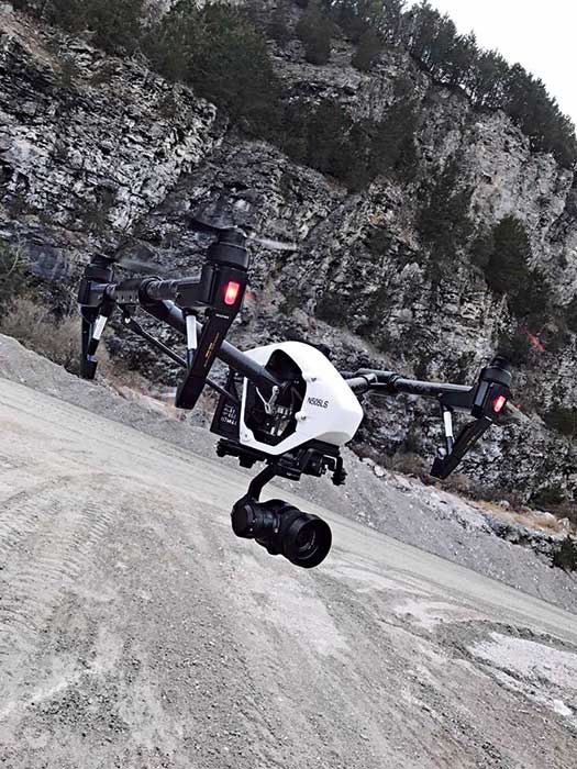
Luck Stone recently began using its UAVs to help with inspection processes. Photos courtesy of Luck Stone
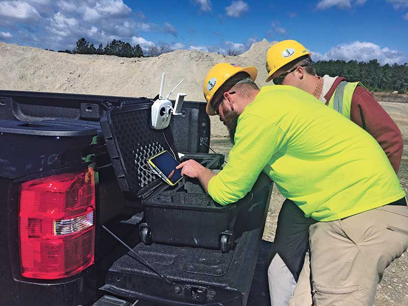
Luck Stone also has an employee completely dedicated to piloting drones and managing the data those drones collect.
“Luck Stone has always been supportive of creativity and innovation,” Blackmore says. “Even though there can be costs associated with exploring, and sometimes not succeeding in, a new method or pursuit, our privately-held company makes room for the introduction of new technologies.”
Eric Warinner, who serves Luck Stone as chief UAV pilot, agrees and adds that company leaders continuously support their employees in the pursuit of innovation.
“At Luck Stone, we accept the failures along with the successes,” Warinner says. “I believe one thing that has set us apart from other mining companies is our leaders’ commitment to the innovation process. With innovation, we understand that there is a healthy process we need to go through that leads us to discovering the most impactful solutions.”
Evolving with innovation
Luck Stone took a next step in its utilization of drones this year by establishing a partnership with Airware, a global provider of commercial enterprise solutions for capturing and analyzing aerial data. Luck Stone was introduced to Airware through its longstanding relationship with Caterpillar, whose dealerships now sell Airware products.
“The biggest draw to Airware was that the analysis and features they provide in their web browser are tasks that our engineering staff were already doing, such as ramp/slope analysis and haul road width analysis,” says Blackmore, whose role at Luck Stone involves managing the company’s UAV and GIS (geographic information system) programs.
Airware representatives pointed out that data collected from flying a UAV could be made available to anybody in the Luck Stone network through Airware’s browser.
“The real draw there was that we could take data and put it into the hands of our operators in the field – our plant managers, truck drivers and pit loader operators,” Blackmore says. “They can see that data and ask different questions than the engineering staff might ask.”
Making data accessible to those who work daily within Luck Stone’s sites offers a number of opportunities, Blackmore adds.
“We’ve got into a rotation with a couple of sites, producing a monthly report for them so they can see changes over time,” he says. “By putting the data in the hands of people who are working at our sites, they can see, for example, how we made a ramp wider and how that affects our haul patterns and cycle times.”
Luck Stone is just scratching the surface on its partnership with Airware, Blackmore adds.
“We’re testing some new features they’re developing that have not yet been released to the public,” he says. “We’re providing them a lot of feedback, talking about things that are going well and areas for improvement. We’re helping them develop their software. It’s definitely a partnership that’s mutually beneficial.”
Data collection
Making data from UAVs accessible to people who work daily within Luck Stone’s sites offers many opportunities.
Warinner is instrumental to the partnership in that he travels to Luck Stone’s many sites to collect sought-after data.
“I handle the field work and the delivery of data,” Warinner says. “I will receive a request from one of our engineers for a map or updated imagery, and it is my job to go out and provide that data in a package that best suits their needs.”
The job puts Warinner on the road most of the time.
“We’ve spent 70 hours in one week trying to get as much data as we can,” he says. “I’ve put 15,000 miles on my vehicle in the past six months. It’s all well worth it because our engineers can really put this data to great use.”
Formulating a schedule for Warinner has been an ongoing process because of the evolving interest from Luck Stone’s engineers.
“Every day is different,” he says. “There isn’t necessarily a set routine in how we do it, but it is priority based. Our No. 1 goal is to provide up-to-date, high-quality data. However, if something needs to be done for a construction job right away, that’s going to take priority.”
As the data collector, Warinner tries to keep a day or two each week open so he can prepare data for users. New uses for Luck Stone’s UAV fleet continue to pop up, though.
“A new project that’s taken off more recently is the use of our UAVs for our inspection processes. We are now able to capture high-resolution imagery of stackers, pulleys, cable connections and more,” Warinner says.
About the Author: Kevin Yanik
Kevin Yanik is editor-in-chief of Pit & Quarry. He can be reached at 216-706-3724 or kyanik@northcoastmedia.net.Subscribe to Pit & Quarry

If you enjoyed this article, subscribe to Pit & Quarry to receive more articles just like it.


